Descrizione
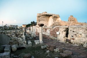
The area takes in the island of Asinara (used as a prison until a few years ago, now a marine and nature park) and the broad shoreline of the central-western sector of the gulf of the same name, the narrow peninsula with Stintino and its hinterland, corresponding to Northern Nurra in the south-west of Porto Torres and to Romangia in the south-east (Sorso and Sennori); extending beyond the municipal area of Sassari, and to the ancient district of Coros (Tissi, Ossi, Cargeghe, Ittiri etc.) south of the city, as far as Osilo to the east, on the border with Anglona, and the municipality of Ploaghe, westerly spur of Logudoro. That which appears on the map as a patchy collection of marine and hilly areas, consisting of pastures and cultivated fields, instead reveals a considerable degree of unity and coherence in historic and cultural terms. Indeed the area is closely linked to the events surrounding the two main urban centres, alternating over the last two thousand years as the economic, political and cultural capital of this region: Turris Libisonis (the present-day Porto Torres) from the Roman Age to the Early Middle Ages, and Sassari from the first few centuries following the year 1000 to today. When the former drew to a close, the latter progressively gained power and prestige, inheriting its economic, political and ecclesiastical functions. The people of Sassari have always regarded the ancient Roman colony and bishop’s seat of Turris as a noble ancestor, a source of historic and religious prestige. Even after the decline of its urban centre, the port of Turris was an indispensable resource for Sassari in terms of the development of the economy and cultural and commercial traffic, growing in importance over the last few years of the 20th century with the building of the chemical-industrial area which led to a considerable demographic and urban development of Sassari, as well as of Porto Torres itself.


Commenti